Archive for the ‘The Great Outdoors’ Category

John Manure Trail

Sunday, July 21st, 2013

7/21/13 – 5 miles.
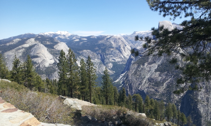
On day one of our hike we woke early in the backpacker campground, boiled water for a quick cup of coffee, and walked a mile through Yosemite National Park to the official starting point of the John Muir Trail. The temperature was cool and the path shady as we climbed the first two miles up a fairly steep canyon. We definitely struggled with our full packs and new muscle demand, but all of us did well and soon put the valley far below. As the morning wore on the sun broke over the mountains and slowed our pace for the last mile before we reached Nevada Falls.

BlogPic

Deadeye had his new solar panel tied to the top of his pack, so the sunny parts of the trail were good for charging but not pleasant for hiking.
We passed two mule trains coming out of the valley and you can probably guess why hikers call this the John “Manure” Trail. Watch where you step!

We are camped at Little Yosemite Valley tonight. Tomorrow X, N, and Dr. Suuz will attempt Half Dome while Deadeye and I will hike to the next camp and wait for them. Deadeye has a sore toe so we thought it best to rest some tomorrow. We hope tomorrow will take us beyond the crowds and noisy camps and into the back country of the beautiful Sierra. I probably won’t have much signal there.

Anza-Borrego State Park

Thursday, March 21st, 2013

After several days of relentless wind and heat near Borrego Springs, Richard and Dianna moved over the mountains to an RV park, while I sought refuge in a more protected section of landscape discovered the day before. I’m still in Anza-Borrego State Park only about 20 miles south of Borrego Springs, but a whole world removed from the wind and oppressive heat. It has been a little breezy but nothing like the howling torrent on the other side of the park. The campground I’m parked in, called Blair Valley, is surrounded by mountains on all sides, quite secluded and pretty, and also quite a bit higher and cooler than the flat lands near town. And even though AT&T has been very disappointing almost everywhere I wilderness camp, I was surprised to find I have excellent cell service.

There are some pretty cool hikes in this area. You wouldn’t think to drive through this place – the term ‘forsaken’ comes to mind – but there are some nice places to hike. Last week we hiked through a slot canyon that twisted for about a half-mile along a narrow, sandstone groove cut by ages of seasonal runoff. In some places we had to turn sideways to squeeze through, while the walls towered way above our heads, blocking out the sun and creating a feel almost like a cave. I have not hiked many slot canyons but this hike has given me the desire to do more of it.

I have also hiked to a place called Palm Canyon. It was a nice five-mile walk on easy terrain with tons of people along the way. The trail follows a canyon to an oasis of palms and gushing water that seem quite out of place in such an arid area. I almost didn’t take enough water; I was thirsty when I got back to the visitors center.

I’ll probably be here for a few more days. There are some nice places to explore and the weather is looking good. I will meet Richard and Dianna in Julian this afternoon. The road to get there looks like fun on a motorcycle – lots of curves.

Campo, CA

Sunday, December 30th, 2012

Just outside a desperate little town on the border between CA and Mexico there is a sign that announces the start of a 2600 mile footpath. The footpath, known as the Pacific Crest National Scenic Trail, traverses the entire western US from Mexico to Canada. Anyone that has hiked the AT can’t help but wonder what it would be like to tackle this monster.

And so today I made my way to Campo CA, to set foot on the southern terminus of the PCT just for the fun of it. As I drove Interstate 8 over the pass through the Vallecito Mountains, the weather started to deteriorate. Dark clouds and spitting snow soon made driving unpleasant to say the least, and it wasn’t until I dropped down out of the mountains and the weather improved that I decided to continue on. I almost turned around and headed back to Arizona.
PCT Start

The start of the PCT wasn’t too hard to find. There are very few roads in the area and no way to get too far south. I eventually spotted a marker where the trail crossed the road and soon came to the ominous, corrugated border fence. It was a short walk up a hill to the PCT southern terminus marker where I took a few photos.

I explored the area for some possible day hikes. The weather need to improve but there are several possibilities. For now I will move back to the desert and hope for better weather.

Short Hike

Friday, November 9th, 2012

I camped last night on a forest service road a few miles west of Forest Lakes. It was a beautiful area, surrounded by a stately grove of Ponderosa Pine, nestled deep within the Apache-Sitgreaves NF. The campground even had toilets.

I was feeling pretty good so I decided to go on a short hike. Earlier, I had stopped at a Ranger Station and obtained literature on places to camp and one of the brochures showed a trail that looped down to Willow Spring Lake. It looked to be about 7 miles. The temperature was perfect for a hike – low 60’s I would guess – and with the coming storm a day away, implored that I shouldn’t wait any longer.

I’m used to hiking on trails that are well marked. I came to several Y’s and had to guess which way to go. Apparently, I chose the wrong trail because I never did find the lake. After hiking a little over an hour, I turned around and came back, probably covering a distance of six miles. I’m glad to report that I feel good and apparently my knee and foot are continuing to improve.

Today, I’ve been hanging out in Payson and will head down to lower altitude for tonight.

Cliff Dwellings

Tuesday, November 6th, 2012

I make lots of mistakes when I write but this word processor isn’t helping any. Now it has removed all my spacing and clumped everything into one paragraph. Even if my spacing is wrong I’m against having the computer change it.

I’ve put 100 miles on the motorcycle already. Roosevelt Lake is long, and I have been to both ends today. I started out in Tonto National Monument where the park service keeps safe the remains of an old cliff dwelling. Looking back at how these people lived and survived gives me a balance when I think of how we live today. Most of the early inhabitants were lucky to live forty years.

The climb up to the site was harder than I thought it should be; maybe I’ve lost some of my conditioning. I was thankful for information plaques along the way where I could rest a few minutes.

When I returned to the Visitor Center I asked the Ranger if there were other cliff dwelling sites in the area, “Oh, there are hundreds of old ruins all over the area.”
“Are any of them open to the public?” I asked.
“They are all open to the public. You can go anyplace on Federal Forest Land. I just can’t tell you where they are.” She smiled.

She did give me a couple of places to look for dwellings down by the Salt River but I drove to both of them and never found anything. She said there were signs but I think they have been taken down for the season.

Tomorrow I will move on to the northeast. I must have a migrational indicator built in – it’s the direction I walked for 6mo.