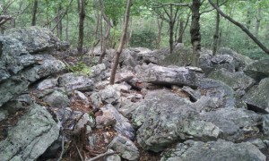
7/12/12 – 1244 miles
One thing about the trail in the north is that you go by more towns. Sometimes the AT goes near a restaurant, and for a hungry hiker, it’s hard to pass them up. I was hiking with SimpleC and his girlfriend when we passed by Blue Mountain Summit Restaurant & BB, an expensive but nice establishment just outside Andreas PA, and decided to stop in for lunch. Needless to say, it was two hours later when I finally dragged my stuffed body back to the trail to finish the days hike.
With a bloated stomach and extra water, I proceeded to hike through a particularly difficult section called the Knife Edge. Pennsylvania rocks ate tough anyway but the Knife Edge lived up to it’s name. Jagged boulders jutting at sharp angles lined the ridge for maybe a quarter mile, and naturally the white blazes led up along the very top of the rocks.
I had filled up on water at the previous spring because of a long dry stretch, and the heaviness of my pack left me with no balance across the boulder field. And my trekking poles were useless on the steep face of the rock. It took me a long time to negotiate the Knife Edge and I hope there is no more like it.

I finally found a reasonably accurate and complete overlay of the AT and all the shelters for Google Earth. It makes finding you and the things you talk about so much easier.
What trail guide are you using, if any?
This is the place that the book authors gave up. It looks like an impossible place to get through.
Can you provide a link to that Richard?
Guy’s website is a http://guymott.com/atgps.html
Here is a direct link to the zip file you want: http://guymott.com/AT/AT_GETrackCollectionFullResolution.zip
There are two kml files in that zip file. One includes the shelters and the other does not.