Archive for the ‘AZT Hike’ Category

Mormon Lake Hike

Monday, June 20th, 2016
AZT

AZT

It all started a few years ago when Daryl and I backpacked to the bottom of Grand Canyon. It was then that I realized this trail through the Canyon was part of the famous Arizona Trail, a continous footpath running 800 miles across Arizona from the Huachuca Mountains on the border of Mexico to the Kaibab Plateau in Utah. I remember thinking then that it would be neat to hike the whole thing.

Since our hike of the Grand Canyon, I have completed about 450 miles of the AZT and Daryl has joined me for the last 100 miles of the trail. I’m not sure if I will ever complete the whole thing but having Daryl to hike with has made it a lot easier to keep going.

Because of the fires in Arizona, the blistering weather, and availability of shuttles from Richard, we have had to skip around a bit. This weekend we hiked a 33 mile section that goes from below Mormon Lake to a few miles south of Flagstaff. Except for a few hills, the terrain was fairly level, and we had little trouble finding good water along the way.

We spent the first night at a forest campground that was quite expensive but reasonable when we factored in my senior pass and split the bill. It was nice to have a picnic table for meals, water that we didn’t have to filter, and a flush toilet.

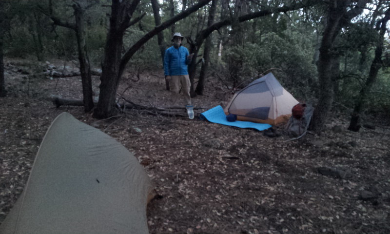
The second night we stayed beside a pretty meadow with a spring just a hundred yards down a side trail. During the night an elk came close to our tents and bugled a few times to make sure we were awake.

Because of long mileage on the second day, the third day was short and we arrived back at our car by 10:00 am. I think we were smart to wake each day at 5 am and get an early start before it got hot. Most of the trail was in pine forest, but by mid day the sun would find its way through the branches, looking for skin we missed when applying sunscreen.

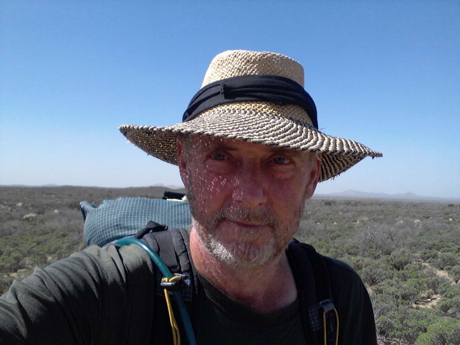
I felt good on this hike. We both had some tender feet from the rocky trail on the first day and I was attacked by malicious mosquitos on the second morning, leaving me scratching my legs throughout the day. But we both had a good appetites and even slept well through the night. And even though I understand the physics behind it, it always amazes me what a temperature swing there is in an Arizona night. When you crawl in your tent at bedtime, it is too warm to do anything but lay atop your sleeping bag, and through the night you gradually bundle inside the bag until the chill of morning makes you reluctant to even crawl out.

I think they have finally fixed my motorcycle and I will make a mad dash into town to pick it up next week. Phoenix is expecting temperatures close to 120 degrees this weekend so I don’t want to tarry long in town. I’m not sure of my plans for this summer but I will definitely look for cooler weather.

Backpacking the Rim

Sunday, May 22nd, 2016
First Campsite

First Campsite

Over this last weekend Daryl and I did a 36 mile, backpacking hike on the Arizona trail. It turned out to be quite challenging for me. My knee has been feeling strong with very little pain, and so I though a weekend hike would be a fairly easy trek. What I underestimated was the strenuous terrain of the trail, the sad fact I’m quite out of shape, and I hate to admit it but I’m getting older.

I’m still waiting for my motorcycle to be fixed. The good news is that they think they know what the problem is, ordered the parts, and should have it fixed by the end of this week. With all this waiting in Arizona, Daryl and I decided to hike a section of the Arizona Trail from Pine Trailhead to Blue Ridge Ranger Station where Richard and Dianna would shuttle us back to our vehicles.

Daryl met me at the trailhead in the afternoon on Thursday and we hiked less than 5 miles to a place called Bear Springs. We found the tank below the spring empty but we were able to walk up the soggy grass above the trail, dig a hole, let the water run until it was clear, and filter enough for the night. I was already tired and lacked an appetite but I managed to eat part of a Mountain House dinner. We were in bed at dark and I slept hardly at all.

The next day we walked 12 miles to to the base of the Mogollon Rim to a place called Washington Park Trailhead. With very little sleep the night before and the constant climbing over hills and through ravines, I basically “hit a wall” when we arrived there. We filtered water from the East Verde and picked out a place to camp that was not great but worked for the night. I had just enough room to set up my tent and Daryl cowboy camped under the stars. I ate very little and was in bed at 7pm.

The next morning I felt somewhat better after a good nights sleep and we set off to climb what seemed like a 60 degree slope for two miles. The two good things about climbing to the top of the rim were the facts that only about a mile was rediculously steep and the wind was blowing hurricane force at our backs, helping us along.

The winds had been strong for several days but nothing compared to the way it howled on the face of the rim. Once we crested the top and hiked back into the Ponderoda Pine forest, the wind still gusted but the trees blocked much of it.

Through the forest the walking was fairly easy. A lot of the path was level and the pines had laid down a carpet of soft needles for us to walk on. We made camp Saturday night in a steep valley called Clear Creek. There was no water where the trail crossed so we explored up the riverbed until Daryl found a small pool at the edge of the gravel. The pool was full of polliwogs, but we filtered them out and the water tasted surprisingly good.

We made camp on a grassy shelf by the riverbed, Daryl used his satellite phone to let family know we were okay and our ETA. We ate a good dinner and were in bed before dark.

Sunday on the AZT gave us only one climb out of the canyon. We took our time knowing we would reach Richard and Dianna midday. The trail was good and we arrived at their home before noon.

I had a good time even though it was tough. Except for the constant wind the weather was great. We had to wear a jacket in the morning but as soon as we started hiking a t-shirt and shorts were our attire. We met one thruhiker. A lady named Anne who we caught early on the third day. We also met a man that rode his bike from Ajo and pushed it up the rim.

Thanks to Richard and Dianna for a welcome shower, a delicious lunch, and a generous shuttle back to our vehicles. They have always been my “Trail Angels” for hiking the AZT.

I will hang out up here in the high country till this weekend and then drive down to Mom’s birthday party. Then I’m hoping my Honda will be ready to travel new places and find more adventure.

Picket Post

Wednesday, March 19th, 2014

3/16/14 – 301 miles

Tired Hiker

Tired Hiker


I was up early and on the trail by first light, confident that I could reach the end of my section hike and fall back into the real world of beds and greasy food. It wasn’t so much that I was tired of hiking, although I had developed a couple of blisters, but that my body was ready for a rest. It had been six days on the trail with very little water to spare and food supplies running low, and the longest stretch of my hiking career without seeing a soul. I vowed to enjoy the day and not waste the beauty of this section by focusing only on getting done. But when your foot hurts, the pack seems way heavier than it ever did before, you smell somewhat worse than a billy goat, and you are partially dehydrated from not drinking enough liquid, it’s hard not to think only of the end.

The section above the Gila River really was beautiful. The trail winds up into high canyon cliffs with views for miles in several directions. There were awesome formations of jutting rocks and buttes that gave the area an almost other-worldly appearance. The canyon is so remote and isolated that few people ever get to see it. It was quite a taxing climb up and out of the section, and I have to admit I was a little discouraged that what appeared to be the top only wound around more formations and dropped me down through another ravine and back up again, but the sights made it bearable. I finally was able to get a cell signal and give Richard the heads up that I would arrive at the end that afternoon. From that point on I was down behind mountains and would not have another chance to update my eta.

It was a lot easier walking when I entered the last section and I made good time to a place called Trough Springs. I was really thirsty by that time and needed water badly. Trough Springs is a place I have been to before. When Daryl, Donna, and I did a short backpack trip a few years ago we chose a route that let us camp near the spring on the night of our trip. When we camped there a few years ago the spring was full with good water, but when I arrived this time the trough had about one inch of disgusting slime in the bottom. This was bad news. I had another 8 miles to hike and I was not looking forward to going that distance without water.

After some investigation I found a 24 inch round pipe sticking out of the ground above the cattle trough and went to check it out. When I removed the cover and peered down into the well I could see water about 8 feet down. At first I thought there was no way I would ever be able to get to the water, but with a little ingenuity I fashioned a bottle tied to a long stick and was able to dip water from the well. I left the stick and twine I used to tie on the bottle in hopes that the next hiker would be able to “fish” the same way I did.

When I arrived ad Picket Post Trailhead, I finally got a text to go through to Richard and Dianna and they were there shortly to pick me up. Someone had left several gallons of water beside the trail and I used some for washing up a bit. I know it was for drinking but every thruhiker will go into town when they get there and not be as affected by their water supply.

Most of the AZT was marked well and easy to follow. There were a couple of places where the markers were missing and the trail somewhat unclear where it went, but most of the way was easy to follow. I will probably send out a note to the Trail Conference telling them where I was confused and on one instance lost for a few miles. I used only the guide book for navigation and I would suggest getting the route on GPS along with detailed maps showing all distances and water sources. Each item you use for navigation and information cost more money – which I was reluctant to spend – but probably would be worth it in the long run. I’m glad I took a water filter because a lot of the water sources are stagnate ponds. Even though you can make water safe to drink with chemicals it is nice to run it through a filter to remove all the gunk floating around in it.

It was a good hike:
– On the AT I never had to worry much about water.
– On the AZT I never had to worry much about rain.

– On the AT the trail was almost always in the shade.
– On the AZT I could almost always get a good charge on my solar panel.

– On the AT someone was always around in case you were hurt or sick or just wanted company.
– On the AZT you could be alone and enjoy the solitude of being one with nature.

– On the AT it is easier to hitch into town from the trail.
– On the AZT I had two wonderful trail angels following me all the way.

Godzilla!

Sunday, March 16th, 2014

3/15/14 – 284 miles.

Gila Monster

Gila Monster


In some sections of the trail industrious builders have created giant, stone cairns to mark the path. Some of them were waist high and one was almost to my shoulders. Every time I would pass one a little lizard would run to the top of the cairn, taking up a post like a guard in the watchtower, then diving to the safety of the rocks as I came close. I have seen hundreds of these little guys, but I was not expecting to see the big guy I came across this morning.

I spent most of the day walking beside the Gila River. The trail would climb up to the high ridge above the valley and give splended views, then descend into the flat land of mesquite forests with camping available everywhere. It was on one of the ridges when I rounded a switchback and came face to face with a Gila Monster. He was not friendly at all. He would open his mouth and hiss at me, as if to say: Get off my trail! I got off the trail and went around.

So I can add one more critter to my list. He did let me take a couple of pictures from a distance. I guess it is only logical to see a Gila Monster beside the Gila River. My book says there are mountain lions and bighorn sheep in this area. I would love to see a bighorn.

The trail left the river and wound up through a canyon. I stopped after a few miles of climbing and made camp in a wash. I should make it to Picket Post tomorrow. I hope I can get a signal and secure a ride.

Snakes and Scorpions

Friday, March 14th, 2014

3/14/14 – 267 miles.
I never did find the water tank that was mentioned in my guide. It was only 90 feet off the trail so it seems funny that I missed it. All the AZT signs say not to rely on cow tanks – they are the property of the ranchers and you are supposed to get permission to even use them.

I started out early while it was cool and rationed what remaining water I had left. The flat desert soon changed to canyons and tall hills. It was a lot prettier to walk through but the climbs made me more thirsty. I arrived at Florence – Kelvin Highway -where there is a water cashe – about noon and drank a half-gallon of water before filling up my bottles and moving on.

This next stretch follows the Gila River for 16 miles so I will have water for a while. The trouble with the Gila is that it is muddy. I filled my bottles and will let them sit overnight to see if any of the mud will settle before running it through my filter.

I have seen 4 snakes, countless deer, 1 wild pig, jackrabbits, 1 mountain lion, 1 scorpion, 1 turtle, and hundreds of cows. None of the snakes were venomous, I squished the scorpion, and everything else ran away.

The cows that are pastured in the desert sometimes make a mess of the trail. They are forever making their own path and breaking down the edges of the trail. And they cut switchbacks all the time. They think the shortest distance is the best route.